
Repository Summary
| Description | |
| Checkout URI | https://github.com/mogi-ros/week-7-8-ros2-navigation.git |
| VCS Type | git |
| VCS Version | main |
| Last Updated | 2025-02-09 |
| Dev Status | UNKNOWN |
| Released | UNRELEASED |
| Contributing |
Help Wanted (-)
Good First Issues (-) Pull Requests to Review (-) |
Packages
| Name | Version |
|---|---|
| bme_ros2_navigation | 1.0.0 |
| bme_ros2_navigation_py | 1.0.0 |
README
Week 7-8: Navigation
This is how far we will get by the end of this lesson:
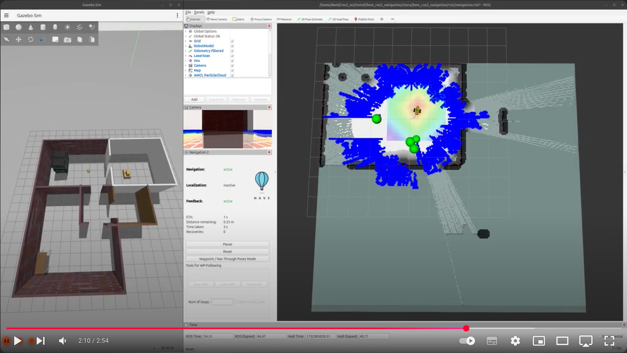
Table of Contents
-
Introduction
1.1. Download ROS package
1.2. Test the starter package -
Mapping
2.1. SLAM toolbox -
Localization
3.1. Localization with AMCL
3.2. Localization with SLAM toolbox -
Navigation
4.1. Waypoint navigation
4.2. Navigation with SLAM - Exploration
Introduction
In this lesson we’ll lear how to map the robot’s environment, how to do localization on an existing map and we’ll learn to use ROS2’s navigation stack.
Download ROS package
To download the starter package, clone the following git repo with the starter-branch (using the -b branch flag) into your colcon workspace:
git clone -b starter-branch https://github.com/MOGI-ROS/Week-7-8-ROS2-Navigation
Let’s take a look what’s inside the bme_ros2_navigation package with the tree command!
.
├── CMakeLists.txt
├── package.xml
├── config
│   ├── amcl_localization.yaml
│   ├── ekf.yaml
│   ├── gz_bridge.yaml
│   ├── navigation.yaml
│   ├── slam_toolbox_localization.yaml
│   ├── slam_toolbox_mapping.yaml
│   └── waypoints.yaml
├── launch
│   ├── check_urdf.launch.py
│   ├── spawn_robot.launch.py
│   └── world.launch.py
├── maps
│   ├── my_map.pgm
│   ├── my_map.yaml
│   ├── serialized.data
│   └── serialized.posegraph
├── meshes
│   ├── lidar.dae
│   ├── mogi_bot.dae
│   └── wheel.dae
├── rviz
│   ├── localization.rviz
│   ├── mapping.rviz
│   ├── navigation.rviz
│   ├── rviz.rviz
│   └── urdf.rviz
├── urdf
│   ├── materials.xacro
│   ├── mogi_bot.gazebo
│   └── mogi_bot.urdf
└── worlds
    ├── empty.sdf
    └── home.sdf
File truncated at 100 lines see the full file
CONTRIBUTING
Repository Summary
| Description | |
| Checkout URI | https://github.com/mogi-ros/week-7-8-ros2-navigation.git |
| VCS Type | git |
| VCS Version | main |
| Last Updated | 2025-02-09 |
| Dev Status | UNKNOWN |
| Released | UNRELEASED |
| Contributing |
Help Wanted (-)
Good First Issues (-) Pull Requests to Review (-) |
Packages
| Name | Version |
|---|---|
| bme_ros2_navigation | 1.0.0 |
| bme_ros2_navigation_py | 1.0.0 |
README
Week 7-8: Navigation
This is how far we will get by the end of this lesson:
Table of Contents
-
Introduction
1.1. Download ROS package
1.2. Test the starter package -
Mapping
2.1. SLAM toolbox -
Localization
3.1. Localization with AMCL
3.2. Localization with SLAM toolbox -
Navigation
4.1. Waypoint navigation
4.2. Navigation with SLAM - Exploration
Introduction
In this lesson we’ll lear how to map the robot’s environment, how to do localization on an existing map and we’ll learn to use ROS2’s navigation stack.
Download ROS package
To download the starter package, clone the following git repo with the starter-branch (using the -b branch flag) into your colcon workspace:
git clone -b starter-branch https://github.com/MOGI-ROS/Week-7-8-ROS2-Navigation
Let’s take a look what’s inside the bme_ros2_navigation package with the tree command!
.
├── CMakeLists.txt
├── package.xml
├── config
│   ├── amcl_localization.yaml
│   ├── ekf.yaml
│   ├── gz_bridge.yaml
│   ├── navigation.yaml
│   ├── slam_toolbox_localization.yaml
│   ├── slam_toolbox_mapping.yaml
│   └── waypoints.yaml
├── launch
│   ├── check_urdf.launch.py
│   ├── spawn_robot.launch.py
│   └── world.launch.py
├── maps
│   ├── my_map.pgm
│   ├── my_map.yaml
│   ├── serialized.data
│   └── serialized.posegraph
├── meshes
│   ├── lidar.dae
│   ├── mogi_bot.dae
│   └── wheel.dae
├── rviz
│   ├── localization.rviz
│   ├── mapping.rviz
│   ├── navigation.rviz
│   ├── rviz.rviz
│   └── urdf.rviz
├── urdf
│   ├── materials.xacro
│   ├── mogi_bot.gazebo
│   └── mogi_bot.urdf
└── worlds
    ├── empty.sdf
    └── home.sdf
File truncated at 100 lines see the full file