
Repository Summary
| Description | |
| Checkout URI | https://github.com/jkk-research/pointcloud_to_grid.git |
| VCS Type | git |
| VCS Version | ros2 |
| Last Updated | 2025-07-24 |
| Dev Status | UNKNOWN |
| Released | UNRELEASED |
| Contributing |
Help Wanted (-)
Good First Issues (-) Pull Requests to Review (-) |
Packages
| Name | Version |
|---|---|
| pointcloud_to_grid | 0.0.0 |
README
pointcloud_to_grid ROS 2 package
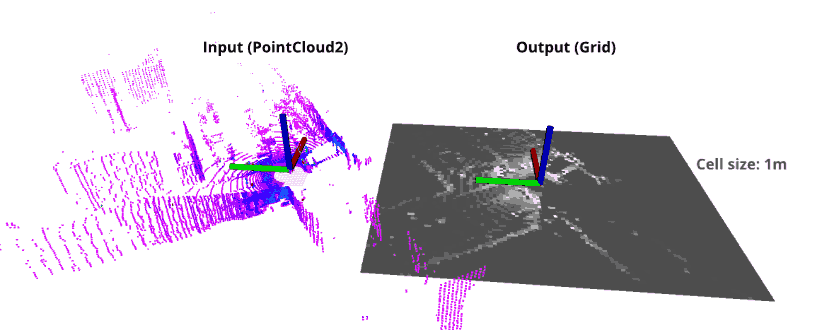
This package converts sensor_msgs/PointCloud2 LIDAR data to both nav_msgs/OccupancyGrid and grid_map_msgs/GridMap 2D map data based on intensity and / or height.
If you would like to use ROS 1 version (melodic, noetic), please go to ROS1 branch.
Build
cd ~/ros2_ws/src
git clone https://github.com/jkk-research/pointcloud_to_grid -b ros2
cd ~/ros2_ws/
colcon build --packages-select pointcloud_to_grid --symlink-install
Don’t foget to source ~/ros2_ws/install/setup.bash.
Features
- Few dependencies (ROS 2, PCL, and grid_map_msgs mainly) ROS installation
-
Dual output format support: Publishes both
nav_msgs/OccupancyGridandgrid_map_msgs/GridMapmessages simultaneously - Simple as possible
- Fast
Conventions & definitions

Getting started
In a new terminal go to your bag folder (e.g. ~/Downloads):
cd ~/Downloads
Download a sample rosbag (~3,3 GB) (TODO: update to ROS 2 mcap`):
wget https://laesze-my.sharepoint.com/:u:/g/personal/herno_o365_sze_hu/EYl_ahy5pgBBhNHt5ZkiBikBoy_j_x95E96rDtTsxueB_A?download=1 -O leaf-2021-04-23-campus.bag
Play rosbag:
ros2 bag play -l ~/Downloads/leaf-2021-04-23-campus.bag
Start the algorithm in a new terminal :
ros2 launch pointcloud_to_grid demo.launch.py
Alternatively, start with subscribing to /my_custom_cloud_topic:
ros2 launch pointcloud_to_grid demo.launch.py topic:=my_custom_cloud_topic
Start the visualization in a new terminal :
ros2 launch pointcloud_to_grid rviz.launch.py
Dual Output Format Support
The package now supports publishing both nav_msgs/OccupancyGrid and grid_map_msgs/GridMap message types simultaneously. This allows for better integration with different ROS 2 packages that may prefer one format over the other.
New Parameters
In addition to the existing parameters, the following new parameters control the GridMap output topics:
| Parameter | Type | Default | Description |
|---|---|---|---|
mapi_gridmap_topic_name |
string | intensity_gridmap |
Topic name for intensity GridMap |
maph_gridmap_topic_name |
string | height_gridmap |
Topic name for height GridMap |
Output Topics
The node now publishes to four topics simultaneously:
OccupancyGrid format:
-
intensity_grid(nav_msgs/OccupancyGrid) -
height_grid(nav_msgs/OccupancyGrid)
GridMap format:
-
intensity_gridmap(grid_map_msgs/GridMap) -
height_gridmap(grid_map_msgs/GridMap)
Usage Example
# Launch with custom GridMap topic names
ros2 launch pointcloud_to_grid demo.launch.py topic:=my_pointcloud mapi_gridmap_topic_name:=my_intensity_map maph_gridmap_topic_name:=my_height_map
QoS Configuration
The package is configured to use BEST_EFFORT reliability QoS policy for the input point cloud subscription. This ensures compatibility with typical LiDAR sensor publishers that often use this policy for performance reasons. This prevents QoS compatibility warnings that might appear with the default RELIABLE policy.
Related solutions
- github.com/ANYbotics/grid_map - This is a C++ library with ROS interface to manage two-dimensional grid maps with multiple data layers.
File truncated at 100 lines see the full file
CONTRIBUTING
Repository Summary
| Description | |
| Checkout URI | https://github.com/jkk-research/pointcloud_to_grid.git |
| VCS Type | git |
| VCS Version | ros2 |
| Last Updated | 2025-07-24 |
| Dev Status | UNKNOWN |
| Released | UNRELEASED |
| Contributing |
Help Wanted (-)
Good First Issues (-) Pull Requests to Review (-) |
Packages
| Name | Version |
|---|---|
| pointcloud_to_grid | 0.0.0 |
README
pointcloud_to_grid ROS 2 package
This package converts sensor_msgs/PointCloud2 LIDAR data to both nav_msgs/OccupancyGrid and grid_map_msgs/GridMap 2D map data based on intensity and / or height.
If you would like to use ROS 1 version (melodic, noetic), please go to ROS1 branch.
Build
cd ~/ros2_ws/src
git clone https://github.com/jkk-research/pointcloud_to_grid -b ros2
cd ~/ros2_ws/
colcon build --packages-select pointcloud_to_grid --symlink-install
Don’t foget to source ~/ros2_ws/install/setup.bash.
Features
- Few dependencies (ROS 2, PCL, and grid_map_msgs mainly) ROS installation
-
Dual output format support: Publishes both
nav_msgs/OccupancyGridandgrid_map_msgs/GridMapmessages simultaneously - Simple as possible
- Fast
Conventions & definitions
Getting started
In a new terminal go to your bag folder (e.g. ~/Downloads):
cd ~/Downloads
Download a sample rosbag (~3,3 GB) (TODO: update to ROS 2 mcap`):
wget https://laesze-my.sharepoint.com/:u:/g/personal/herno_o365_sze_hu/EYl_ahy5pgBBhNHt5ZkiBikBoy_j_x95E96rDtTsxueB_A?download=1 -O leaf-2021-04-23-campus.bag
Play rosbag:
ros2 bag play -l ~/Downloads/leaf-2021-04-23-campus.bag
Start the algorithm in a new terminal :
ros2 launch pointcloud_to_grid demo.launch.py
Alternatively, start with subscribing to /my_custom_cloud_topic:
ros2 launch pointcloud_to_grid demo.launch.py topic:=my_custom_cloud_topic
Start the visualization in a new terminal :
ros2 launch pointcloud_to_grid rviz.launch.py
Dual Output Format Support
The package now supports publishing both nav_msgs/OccupancyGrid and grid_map_msgs/GridMap message types simultaneously. This allows for better integration with different ROS 2 packages that may prefer one format over the other.
New Parameters
In addition to the existing parameters, the following new parameters control the GridMap output topics:
| Parameter | Type | Default | Description |
|---|---|---|---|
mapi_gridmap_topic_name |
string | intensity_gridmap |
Topic name for intensity GridMap |
maph_gridmap_topic_name |
string | height_gridmap |
Topic name for height GridMap |
Output Topics
The node now publishes to four topics simultaneously:
OccupancyGrid format:
-
intensity_grid(nav_msgs/OccupancyGrid) -
height_grid(nav_msgs/OccupancyGrid)
GridMap format:
-
intensity_gridmap(grid_map_msgs/GridMap) -
height_gridmap(grid_map_msgs/GridMap)
Usage Example
# Launch with custom GridMap topic names
ros2 launch pointcloud_to_grid demo.launch.py topic:=my_pointcloud mapi_gridmap_topic_name:=my_intensity_map maph_gridmap_topic_name:=my_height_map
QoS Configuration
The package is configured to use BEST_EFFORT reliability QoS policy for the input point cloud subscription. This ensures compatibility with typical LiDAR sensor publishers that often use this policy for performance reasons. This prevents QoS compatibility warnings that might appear with the default RELIABLE policy.
Related solutions
- github.com/ANYbotics/grid_map - This is a C++ library with ROS interface to manage two-dimensional grid maps with multiple data layers.
File truncated at 100 lines see the full file